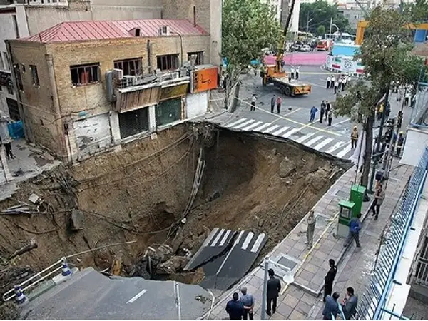
Experts in Iran warn the current land subsidence situation in Iran is “critical", claiming it puts the lives of more than 39 million people at risk.
Several factors have caused the situation to reach breaking point, including dam construction, climate change, inefficient water consumption by agriculture and industries, and the use of underground aquifers as sources for illegal agricultural water extraction wells.
Ali Beitollahi, heading the disaster task force on the issue at the Road, Housing and Urban Development Research Center of Iran, said the approximate area of subsidence zones in the country is now 18.5 million hectares, almost 11% of Iran's total area.
Beitollahi has been warning of the danger for several years, and says if action is not taken, it endangers the lives of nearly 49% of Iran’s population.
He said, ”Three hundred and eighty cities and 9,200 villages are at risk of land subsidence, and in some cases the entire area of the cities are located in the subsidence zones.”
Tehran, Razavi Khorasan in the east and Esfahan in central Iran are the provinces most at risk, Razavi Khorasan in the most imminent danger.
However, international reports claim the danger is even worse, nearing a humanitarian crisis. Science journal claims that more than 98% of Iran's 1.648 million km of land faces land subsidence.
Internationally, a rate of subsidence greater than 4mm per year is considered a crisis and yet Iran's land is sinking at an astonishing rate of 6cm per year as a result of 25 years of water level decline in the plains.
Ground subsidence in urban areas have resulted in power outages, bursting of gas pipes, deformation of rails, emergence of sinkholes, tilting of buildings, the appearance of cracks and ditches in roads and even loss of human life.
Continued water level declines will reduce the ground's water permeability and turn fertile plains into barren deserts.
Kamran Davari from Ferdowsi University of Mashhad, told ISNA state news agency that many cases of subsidence have been reported from some areas in the Mashhad plain in the northeast where subsidence is between at least 3cms and a staggering 15-17.5cms in the northwest of Mashhad city. Davari said the situation had reached “hyper critical”.
Based on the underground water quality zoning map, the areas with good water quality have decreased drastically in Mashhad over the past decade.
"If the electrical conductivity of water exceeds 1,500, it indicates that the water is no longer suitable for drinking,” explained Davari. “Unfortunately, in the eastern areas of Mashhad, the electrical conductivity is currently between 3,000 to 5,000.”
The journal Taylor & Francis Online confirms the fears. In research last year, it claimed: “The province of Razavi Khorasan in the northeast of Iran had the largest area (about 3500 km2) vulnerable to land subsidence occurrence”.
It warned of other risk-prone areas in the future. “Based on the land subsidence susceptibility map, the provinces of Ardabil, Kurdistan, West and East Azerbaijan, Sistan and Baluchistan and Kermanshah, although not currently undergoing a high rate of land subsidence, will be at high risk of severe land subsidence in the future.”
